Entries in geography (30)

Wednesday
Mar292017

travelling landscapes

from Google Maps: 21039 Pacific Coast Highway, Malibu, California

It seems a bit intrusive to peer at the house that Hockney once owned and sold in 1999.  I doubt it had a pool as it was right on the beach beside the Pacific Coast Highway in Malibu.  Now is that a romantic address or what?  This google street view shows the row of fairly humble beach houses on one side of the road, and a rough hill on the other.  Looking up the native vegetation of such a hill, coastal sage scrub, typical of cismontane southern California and northern Mexico, consists of aromatic low-growing shrubs: California sagebrush (Artemisia californica), California buckwheat (Eriogonum fasciculatum), coast brittlebush (Encelia californica), black sage (Salvia mellifera), white sage (Salvia apiana), Lemonade berry (Rhus integrifolia) and Prickly Pear Cactus (Opuntia littoralis). 

I only looked this up as I had been reading about the Corsican macchia, so aromatic that it is the unique scent of Corsica.  The macchia, or in other spellings the maquis, contains crocus (crocus corsicus, Corsican saffron), orchids (Conrad's orchid, serapias nurrica), colchicum, violet, romulea, aconite, garlic, aquilegia, daisy, cyclamen, carnation, digitalis, everlasting, hypericum, forget-me-not, mint, nepeta, ranunculus.  There is heather, narcissi, violets, passionflower, marguerites and mimosa. There is bougainvillea and oleander,  lilac thyme, white and pink broom. Lavender grows wild as does myrtle, rosemary, marjoram and mint.   

Corsica is an ancient and underdeveloped island, Malibu is a highway just north of the freeways of Los Angeles.  This might have something to do with the sparseness of plant life in the coastal sage scrub compared to macchia.  I read somewhere in all of this that one of the problems with coastal sage scrub is the word 'scrub' which gives it little value in the popular imagination. 

My project here, given that the Gulf Islands are said to have a mediterranean climate (ha! not after this winter) and that I am very close to the islands (albeit under a mountain, which might be a problem, part of that rocky spine that is Vancouver Island), is to develop a macchia myself, to turn one's garden into a wild, aromatic ground cover.  Almost every shrub in the Corsican macchia I have seen as singles somewhere in the yard, so they do grow here.  And there are olive trees up island.  And I will add eucalyptus, for that beautiful perfume that so characterises the northern California coastline.  And California poppies, which grow wild by the road.  I see the irony in all of this, but I'm also optimistic.

I think I would quite like to live in Corsica/California/Canada, with olive trees.  It is a bit of a dream, still.

Saturday
Mar112017

Annie Oakley

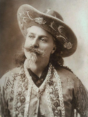
A wistful Buffalo Bill Cody, circa 1890, a couple of years after he had gone to England to visit Queen Victoria.

This has been a week or so, here, of the physical and cultural landscapes of the American southwest, long before malls and freeways, snowbirds, wetbacks and ICE.  The West was a powerful image, for those of us in the west who didn't entirely see it as those in the East might have – fenceless, lawless, full of saguaro cactus and mesas.  Rather those of us in the west north saw it as something our grandparents and parents did.  They knew the flowers, the grasses, the winters, the colourful characters.  Allegedly my great-grandmother had an affair with Robert Service; one grandfather, an executive with Imperial Tobacco in Edmonton, had joined a travelling circus at 13, the other grandfather lived briefly near Olds in a chicken coop, with his school tie, violin and dancing pumps as an apprentice gentleman farmer: these were real, not myth.  

At the same time we were awash with the mythology of the American West as it came through popular culture and that increased to a tsunami after WWII.  For example, there was a tv program for kids about Annie Oakley who had worked for Buffalo Bill, Civil War veteran, Indian hunter, showman, huckster.  In Grade One I got  an Annie Oakley lunch kit.  My brother three years later got a Roy Rogers lunch kit which he promptly lost, for which I don't blame him, it had Dale Evans on it, who was such a drip. 

Annie Oakley, sharpshooter, a little proto-feminist.  In the tv program her sidekick was Tagg, a kid, a boy; her horse was beautiful.  We all drew horses as little girls, before we moved onto ballerinas, leaving the wild west behind.  However, Annie Oakley was a far more exotic model for very little girls than, say, Anne of Green Gables, a book which I could not read at all.  For Annie Oakley there were no rules; for Anne Shirley it was all about fighting the rules that cramped her style.  It made no sense to me.

The west is different from the east; it is another country.

Aladdin Industries Annie Oakley lunch kit, 1955. This one was on Ebay and sold for $350. The cream edges were pressed like leather, and the sides had a belt of bullets running around them.

Monday
May122014

once strong, but now weak, systems

This video, Andy Merrifield outlining the basis for his book The New Urban Question, came by way of Rodrigo Barros, a Chilean architect currently training as a construction logistician for Médecins Sans Frontiers.  Barros did a brilliant piece for On Site review 31: mapping | photography on the 'rightness' of maps that centre on the United States and allow South America to drift off the global view.  His is the view from the South.
 
This particular view, after forty years of intense geopolitical theorising from Latin America, is his lens, and so he picks up on a certain theoretical vocabulary found in Merrifield's brief outline of just how Manuel Castells' explanation of urban social movements has been superseded by a new form of divisive capitalism.  

When states can no longer afford the social services they subsidised in the full flush of postwar capitalist development, their disinvestment in such things as health care and housing pushed such services into the private sector.  This gave rise to urban social movements which struggled to hold governments to their role as keepers of some sort of public faith.  Merrifield feels that the turn to mass privatisation in the 1980s and 90s obliviated urban social movements and that a new paradigm must be developed that returns public space to the public, public health to the public, public housing to the public, the public service to the public.  

Just yesterday there was an interview on CBC with the head of Canada Post whose former position was as the head of Pitney Bowes. There we are. Pitney Bowes is an American private mail and data service for businesses.  Under the Pitney Bowes model, Canadian mail is no longer a public service, it is a corporate business, thus the end of home delivery, the shocking price of stamps and the full support of our current neo-conservative Thatcher/Reaganite form of government. This gives me particular grief.  We are a non-profit publisher with a publications mail contract with Canada Post which gives us a discount on mailing On Site review, except for international mailings which tend never to arrive.  Or if they do arrive it has taken six months to get to, say, Denmark. In contrast, Valery Didion's Criticat is sent from France at a book rate, €2.95, which gets here in a week.  In return I send On Site back to them at publications rate which may or may not get there several months later, or I spend $18 to send it letter mail which gets there in a week.  

Somehow Canada as a wide, dispersed country only sees urban social movements of any consequence in Toronto and Montréal, especially Montréal, infrequently and now rarely, Toronto.  In the rest of the country there isn't the critical mass to act collectively from say, Alberta to Manitoba, so sparse is the population. CBC used to be the glue that held us together, its recent cuts have been lethal.  It is all one with the sacking of scientists, the gutting of census collection and analysis, the cutting free of wounded Canadian Forces from their pensions, cutbacks to universities: the private sector is supposed to be picking up the slack, but it isn't.  And the time is past, according to Merrifield, for Castells' urban social movements to have any influence at all.  In this country, we missed that phase altogether.  

Wednesday
Mar052014

John Thomas Serres: an artist in the Channel Fleet, 1799-1800

John Thomas Serres, Point de Roquilon, France. Captain M. K. Barritt. Eyes of the Admiralty: J T Serres, An Artist in the Channel Fleet, 1799-1800. London: National Maritime Museum, 2014. Image: United Kingdom Hydrographic Office. Don't think you'll find it on the UKHO website however, this appears to be a working website of great complexity for contemporary documents, maps, charts and shipping publications.

About the time I was young and tooling around on a little sailboat in Nanaimo Harbour, I found a book of drawings of the BC coast done by an artist on Captain Vancouver's ship. They looked much like Serres' paintings (above) – navigation charts, meant to point out signal points, rocks bays, harbours and dangers.  These and Vancouver's drawings, which I've never been able to find again, delineated land, not from land itself but from an opposing position on the water.  The land is the objective other.  

It is interesting, from our map-dominated representations of land today, that in the eighteenth century elevations were as necessary as reckoning by the sun: they are visual one-to-one maps without translation to a plan.  Of course they eventually had charts, but Vancouver was in uncharted territory: a drawing or a painting bypassed translation, gave the context and the scale of the coast, especially if it was potentially hostile.  

From the water, the land-bound built environment is very small – a toytown between the sky, the mountains and the sea, all huge. Even approaching a city such as Vancouver by ferry, its complex urbanity is itself but a pale cluster, not very tall, almost irrelevant.  From the middle of the strait one can see that the Island is the top of a mountain range, that the strait is full of small islands, that there are dozens of boats from tugs to freighters, container ships to barges: daily life on a terrain that remains mysterious to those on land.

Tuesday
Feb182014

Nancy Holt: 1938-2014

Nancy Holt. Sun Tunnels, completed in 1976. Photographed by Mary Kavanagh (image is linked to her site). Four large concrete tubes are arranged in an open X. The 9' diam x 18' long sections of culvert are pierced by holes of varying size that correspond to the pattern of the constellations Draco, Perseus, Columba and Capricorn. The tunnels line up with the rising and setting sun on the summer and winter solstices.

Nancy Holt, who died last week, was one of the original land artists working in New Mexico, Utah and Arizona, along with Dennis Oppenheimer, Michael Heizer, James Turrell, Walter de Maria and Robert Smithson, all of whom had little time for the constricting space and rules of urban galleries and art museums.  They said they were making art for the land, the ultimate expression of 1960s freedom – at the beginnings of the environmental movement and working at the scale of infrastructure, the military and the mining industry.

Land Art had its roots in Minimalism and Conceptual Art, where 'art products' are often ephemeral, unrecognisable or self-destructing.  Looking back on it now it appears as a real struggle to return agency to the artist: Nancy Holt bought the 40 acres of Utah desert for Sun Tunnels, and hired, as she listed: '2 engineers, 1 astrophysicist, 1 astronomer, 1 surveyor and his assistant, 1 road grader, 2 dump truck operators, 1 carpenter, 3 ditch diggers, 1 concrete mixing truck operator, 1 concrete foreman, 10 concrete pipe company workers, 2 core-drillers, 4 truck drivers, 1 crane operator, 1 rigger, 2 cameramen, 2 soundmen, 1 helicopter pilot and 4 photography lab workers' to install it. Plus the culverts.  

The places that Land Artists worked were marginal – in those vast deserts of the American southwest, there were hardly any roads.  When in 1982 Reyner Banham wrote Scenes in America Deserta, a reprise of Charles Doughty's 1888 Travels in Arabia Deserta, Banham was well aware of the elision of desert and deserted.  And in the mid 1990s when I tried to plot a winter route from central Texas to Calgary through all the flat bits, I found one cannot cross Nevada from north to south.  This is a deserta militaria, for most of those deserts are used as test sites, training exercises, speed tests and places to go mad in.

Nancy Holt did not go mad; she married Robert Smithson and continued to work in land art, film and photography from France to Finland and across the United States.  There was an exhibit of her photographs last year at Vancouver's Contemporary Art Gallery, whence this lovely image comes.

Nancy Holt, Concrete Poem, 1968. composite inkjet print on archival rag paper taken from original 126 format black and white negatives, printed 2012

Tuesday
Feb042014

Anselm Kiefer: Wilder Kaiser, 1975

Anselm Kiefer. Wilder Kaiser, 1975. Watercolour and acrylic on paper; 6 3/8 x 9 1/2 in. (16.2 x 24.1 cm). Metropolitan Museum of Art 1995.14.11

Because I was thinking about Keifer after thinking about Gerhard Marx's grass and mud drawings of Johannesburg, I came across this drawing he did in 1975 of what the Met describes as 'the limestone massif of the Kaiser mountain range in northern Tyrol', the Kaisergebirge.  The Wilder Kaiser is one ridge, the other is lower and rounder, the Zahmer Kaiser. Somehow, living next to the Rocky Mountain Range, and driving back and forth 1100km to the coast through this range, the Selkirks and the Coast Range, a range of two ridges seems rather European.   

Nonetheless, and that is irrelevant, Keifer's Wilder Kaiser is a gesso crag in a watercolour sea.  Evidently he worked from a map and included a bit of cartographic information for Predigtstuhl: 2083m.  

Because the next issue of On Site review is on mapping, and because it was -26 this morning and it is a tad chilly about the edges here, this particular drawing appeals.  Keifer's mapping shows the limits of perception: either what you can see or what you want to know, both necessarily limited.  The size of the subject, here a mountain, has nothing to do with the size of a map, or a drawing, or a thought.  The name stands in for the range, the gesso peak for one of the individual peaks in it.

Conventional mapping flattens a complex and emotional world to a flat sheet, coded to illustrate topography, and imposing an equivalence on all information that is distinctly misleading.  And yet it is so pervasive it has us running around on the surface of the world as if we were on charts, and as if we are incapable of holding opposing thoughts and perceptions in our heads.  Yes Predigtstuhl is part of the Wilder Kaiser, but yes too, it is separate from it.  For this we need artists.

Wednesday
Aug082012

The Deep of the Modern: Manifesta 9

Coal Sack Ceiling homage to Marcel Duchamp, Manifesta 9. Photograph: Kristof Vrancken/Association Marcel Duchamp, Paris

This year, the biennial Manifesta is centred on the Waterschei mine in Genk, in in the coal-mining region of Belgium.  Adrian Searle has written a fulsome review of it in the Guardian, and there is a slide show of some of the work here.  
Searle talks about the Bechers and their recording of the industrial landscapes and infrastructure of eastern Belgium, Holland and the northern Ruhr, where Manifesta 9 is being held.  The Bechers are in this exhibition as well, but the arresting image of the coal sacks indicates the interventionist nature of some of the work, beyond the recording of landscapes that shock by their mere presence alone.

The catalogue is here.  The first paragraph of the curatorial concept for Manifesta 9 states, 'The Deep of the Modern intends to create a complex dialogue between different layers of art and history. Its point of departure is the geographical location itself—the former coal-mining region of the Campine in north-eastern Belgium as a locus for diverse issues, both imaginary and ecological, aligned to industrial capitalism as a global phenomenon. Manifesta 9 takes its cue from the previously abandoned, recently restored Waterschei mine complex in Genk.'

The Deep of the Modern.  What a title.  The image above is an homage to Duchamp's 16 Miles of String of 1942. This free ranging through the twentieth century of art and industry, production and politics shows how they inflect each other, rather than presenting the isolation of each of these activities into the discrete silos that they have generally pretended to be.  This is an obvious and natural discussion of the world in which art is an integral part, however it signals a big change from late twentieth century art discourse.

On Site 26:DIRT looked at the surface of the earth, issue 27:rural urbanism investigated in many of the articles how the earth, the dirt, agriculture, the mines and resource-extraction industries locate cities.  On Site 28: geology, next spring, will be continue this discussion of geological consequences and how we are both shaped by them and try to intervene in them ourselves. 

Thursday
Apr262012

higher ground

Rebuilt trenches at Vimy RidgeNot sure where I found this image, it has been on my desktop for months.  It presents the structure of the trenches, no long shots or avenues, the depth, the configuration, all of which take on, today, the appearance of a land art installation.  However, like yesterday's map of the Gallipoli Peninsula, there is high ground, full of threat, and there are valleys, where one is. 

It is, I suppose, psychogeography 101, that being visual beings, we like being high up in the landscape so that we can see what is below us.  Why else would new subdivisions have names such as Aspen Heights, and, in west Calgary, the confusing Valley Ridge? which is on the side of a valley, but clearly has aspirations.

JB Jackson's essay, 'Landscape Seen by the Military' compared the fields of war in Europe during WWII where he was a military intelligence officer, with peacetime land use: ordered, hierarchical, topographical.  He seemed to imply that war was just another social aspect of how we use land. I'm not sure about this relatively limp thesis, that we have pushed and shaped the land to map our sense of what is right and proper, and that the land has let us.  Well, we have pushed it around, but the land resists.  The trenches in farm fields in northern France were full of water for one thing: a high water table (which is what made them so fertile) and, in 1916, unusually bad weather.  The suicidal Gallipoli situation – the land was not the ANZAC's ally, nor was it for D-Day – again, men scrambling up beaches while batteries of guns at the top of the cliffs (whose erosion makes the beaches) fired down at them. 

Vitruvius has a whole section on the advantages of height: it is safer there.

Thursday
Feb022012

Oxbow, Saskatchewan

Oxbow, Saskatchewan.

The classic prairie town: CPR tracks, Railway Avenue, Main Street crossing at right angles to it, the old town neatly conscribed by the section lines, the new town spilling north into the adjacent quarter-sections.  
Oil is near, developed in the mid-1950s, there is still a grain elevator, dating from the early 1900s, the oxbow is on the Souris River, population 1200, Highway 18 from the Manitoba border to Estevan follows the CPR line and becomes Railway Avenue as it divides the town from the elevator and its outbuildings.

 
Oxbow, Saskatchewan. Google Maps
There used to be one of these towns every 6 miles, or every township.  Now when you drive through southern Saskatchewan often all one sees is a roadside plaque saying that there had, once, been a town there.

We are such a long way from Monday and the Battle of Alesia.

Wednesday
Feb012012

oxbows

John Macoun. Manitoba and the Great North-West : the Field for Investment; the Home of the Emigrant, Being a Full and Complete History of the Country. Guelph: World Publishing Company, 1882

In St Boniface, above, one can see the remains of an oxbow from the Red River. Detached from the main flow, it would have become, as indicated in this 1882 map, a slough perhaps flooding each spring.  Not to worry, the street grid has been drawn over it anyway, good flat land for development.  Just to the west (the map has west at the top) of the oxbow one can see the old seigneurial land divisions: thin narrow lots fronting on the river.
In the google satellite view, below, the edge of the oxbow is Enfield Crescent, the eccentric in the grid.  The seigneurial pattern is gone, but the road that skirted the swamp (also long gone) remains, permanently embedded in the street layout.

St. Boniface, Winnipeg: from Google Maps, rotated 90° clockwise to match the 1882 map.

Tuesday
Jan312012

meanders

Harold N. Fisk, Ancient Courses. Mississippi River Meander Belt, 1944

The greek key pattern is sometimes called the meander, after the Maeander River, now called the Büyük Menderes River that flows from central Turkey to the Aegean.  It winds through the Maeandrian plain in the manner of most prairie rivers, cutting into soft banks and creating oxbows.  

Thursday
Nov102011

Donovan Wylie 2: the architecture of war

Tuesday
Jun282011

rivers and borders

International Joint Commission map of the Souris River Basin

The Souris River is flooding Minot, North Dakota.  On the CBC news a Minot resident blames Saskatchewan for this, 'they should have done something'.  The Souris eventually joins the Assiniboine, after it crosses the border again, back into Manitoba.  The Assiniboine flooded earlier this spring and will perhaps flood again.  Winnipeg also keeps its eye on Fargo, North Dakota, on the Red River.  The Assiniboine joins the Red in downtown Winnipeg.  In the 1996 Red River flood Winnipegers blamed Fargo for not better controlling the river flow. 

BC Treaty Commission. Statement of Intent. Traditional Territory Boundary, Sliammon Indian Band.The 49th parallel is an abstract political division that serenely ignores topography: global mathematics trumps geophysical realities.  Before the US Survey, before the Dominion Grid, before enlightened Europeans started to delineate territory in this seemingly empty-ish land, there were aboriginal territories: precise, negotiated at their borders by treaty, surveyed orally in a metes and bounds system.  
Sliammon First Nation territory clearly is topographically based: it controls the watershed on the western slopes of the Coast range, the waterway and fishing beds of the inland passage and the opposite beach, securing the whole width of the strait.  Fresh water systems, food, sea borne transportation capacity, security: these are the things that boundaries delineate. 

 Arid Region of the United States, showing drainage districts. Maureen and Mike Mansfield Library, The University of Montana-MissoulaThis 1891 map of watersheds in what was called the arid regions of the western United States shows a division of land that could have been a series of small states, with control over their own water resources and all the potential agricultural and animal resources a watershed contains.


Pre-contact North American cultural areasOr, looking at a map of pre-contact cultural zones in North America, one can see how there is a huge territory that controls the Great Lakes.  Another has the whole western watershed of the Mississipi, another group the eastern side.  The Great Divide separates the peoples of the watersheds that go to the Pacific from those of the plains: the north to Hudson's Bay, south to the Gulf of Mexico.  The boreal forest is one huge cultural group, as is the high Arctic. 

Topological environmental divisions as political territories: what a novel idea.  One could only blame oneself for mismanaging one's resources.

Tuesday
May312011

Rouleau, Saskatchewan

George Hunter. Rouleau, Saskatchewan 1954. CCA Archives.

Rouleau, Saskatchewan (1903), photographed from the air by George Hunter in 1954.  This is the classic image of a prairie town, located within the Dominion Grid (laid down between 1879 and 1884), wood grain elevators lining the tracks, the world of Who Has Seen the Wind (1947), a train stop on the SOO Line (to Chicago) built during the wheat boom that ended sharply in 1910.  Lots of dates, but all within the space of fifty years.

Rouleau, Saskatchewan. Google Maps, 2011Rouleau on GoogleMaps.  Not a lot has changed.  Rouleau is in the infamous Palliser Triangle, an area (officially a semi-arid nutrient-rich steppe) deemed by John Palliser, who surveyed it in 1858, to be uninhabitable because it didn't support trees.  The whole area suffered greatly during the droughts of the 1930s, but nearby is Claybank Brick Plant, now a historic site.  The clay was particularly suited to firebrick, used to line fire boxes in train and ship engines: CPR, CNR and RCN all in expansion mode up to WWII  – voracious clients for firebrick.

From 2003 to 2008  Corner Gas was filmed in Rouleau.  The iconic Saskatchewan rural wheat town was the physical fabric that supported a vision of Canada as a friendly but sometimes sharp-edged community, funny, pathetic, brave, funny, ridiculous, heroic, funny, everyday.  Corner Gas was the Canada that we like to carry about within us, without actually living there.  

Rouleau's slogan is 'Saskatchewan's First 1 Million Bushel Town!'  Does this mean much to any of us not from a farming background? No.  Does Rouleau care?  No.  Is this a brand?  No.  Does this say a lot about Rouleau?  Yes.

Thursday
May262011

Gerster 2: land prints

Gerog Gerster. Harvest, Idaho, 1988

Is ploughing, cutting and threshing so individual that their patterns act as a fingerprint?  Something like the individuality of a welder's seam?

I would hazard that these are fields not part of the Dominion Survey, or in the States, the Land Ordinance Act, both of which divided the land into a 6 mile grid, implacable and immutable.  Such fields are square, ploughed squarely, unless there is a slough, or an erratic, or some awkward bit of topography in the way.  Or maybe farmers just get bored.

Well, no. The point of contour ploughing is to increase water retention in sloping soil and to prevent water erosion, survey grids notwithstanding. So something indicates the need for water conservation in these fields.

Gerster seems to have returned to this area, eastern Washington and Idaho many times.  Almost all his work, which is from all over the world, is about the interaction of industrial practice with the landscape – the mark of man, the hand, the machine and the land.  

Georg Gerster. Lentils, USA, 1980

Wednesday
May252011

Georg Gerstner: land

Georg Gerster. Felder im Palouse, USA, 1979

Okay, done with the hand for now, the closest landscape we have.  Georg Gerster, German photographer, did a lot of aerials from helicopter and small planes from the 60s to 90s.  Beautiful photography, National Geographic stuff, very photogenic landscapes.  The one above, found in his photo gallery on his website, is a ploughed field in eastern Washington State, near Palouse, shot in 1979.  

Wonderfully graphic, one does have to ask why it is so.  Looked up the area around Palouse on Google Maps and found that on the western slope of the Rockies it is indeed highly topographic, contour ploughing raised to land art.

We have a call for articles out for issue 26: dirt.  Land is dirt, dirt grows crops, crops determine planting and harvesting with large machines these days, those machines make patterns and we find them often enchanting.  


Google Maps: Palouse Washington USA

Monday
Mar212011

dust

Approaching dust storm, Fort MacLeod, Alberta. 1930s. Glenbow Museum Archives NA-2928-28So, is this weather, or the result of a war with the land?  Literally tons of soil blew east from the centre of North America dropping on the east coast and the Atlantic Ocean during the 1930s: a drought combined with very poor farming practices that stripped the prairies of the indigenous grasses that held the soil and moisture in place with their roots. 

It made excellent mulch, evidently.  Of course it would; fine topsoil, perfect for planting seedlings.  The process of getting it spread all over your fields however was catastrophic.  

Friday
Mar182011

dirt

The Great Dust heap at Kings Cross. Photograph: Wellcome Images/Wellcome Library, LondonThere is a new exhibition at the Wellcome Library about dirt and our changing views of cleanliness.  A very good write-up by Christopher Turner is on today's Guardian website.

Dirt is also the theme for the upcoming Fall issue of On Site (see the call for articles here). 

The exhibition at the Wellcome, a medical library, is based on Virginia Smith's book, Dirt: the filthy reality of everyday life, a historic survey of our attitudes to dirt and propriety that affects every corner of our dusty lives, our buildings and our cities. 

Living on the prairies is characterised by a fine black dust that blows off the land and settles on windowsills even at the heart of the city.  One is always dusting, sweeping, shaking out mops.  Our streets in Calgary are washed once a year, a great production of fleets of street sweepers, water sprinklers and then another pass by the sweepers.  There isn't a lot of rain here, so the streets and consequently the air are dusty again almost immediately.  Now, on the coast, where it rains all the time and one has to work hard to find dust, even fine dirt in the gravel bed that is the back vegetable garden, these streets are washed 4 or 5 times a year. 

It seems that this is an issue of perception.  On the prairies, dust, gumbo, mud, grey film, clouds of dust off unpaved roads and city alleys – that's okay.  Blowing grit on city streets that gets in your eyes, your hair, your collar – no problem evidently, until you go to a very clean city where the sidewalks are clean, the air is rain-washed, your white dog is actually white, then you realise how slapdash the cleanliness factor can be elsewhere. 

Friday
Feb252011

company towns

George Hunter. Flin Flon, Manitoba, 1960. gelatin silver print. Collection CCA PH2009:0006:014. Gift of George Hunter. copyright George HunterThe Canadian Centre for Architecture holds the photographic archives of George Hunter, a photographer who, in the 1950s, photographed Canada's towns and cities from his light plane.  There is a series of mining towns, of which Flin Flon, above, was one.  As many of these were company towns, the series of eight images on the CCA website might be interesting to anyone who is working on our OIL: a new town competition/exhibition. 

Housing in such places is always laid down with zero concern for personal identity.  Is this to do with company priorities, or was there little concern for personal identity in the 1950s in general.  This dreary subdivision from 1958, Mayfair, is now quite a good Calgary neighbourhood.  We have the luxury of thinking about identity as we, in Canada generally, are wealthy and peaceful enough to think of such things.

Looking east on 66th Avenue (later Glenmore Trail) toward Elbow Drive, Calgary, May 7, 1958. Glenbow Archives File number: NA-5093-466

Wednesday
Feb232011

North African distances


The Western Desert. WWIIGaddafi expelled all Italians from Libya in 1970.  Libya had been the North African staging post for the Italian-German axis in WWII, as Libya had been under Italian control/occupation since the 19th century.

On Al Jazeera last night there was a map of the north coast of Libya with Tubruq on it which, when it was known as Tobruk, was the site of a major and extended battle during WWII.  Rommel held Tobruk for 240 days and then lost it to the Eighth Army.

On the maps we are seeing on the news, one realises just how close Tunisia and Libya are to Sicily.  Lampedusa, a miniature and bleak little island 70 miles off the coast of Tunisia is still part of Italy and until 1994 had a US Coast Guard base on it, used to monitor Libya and fired upon by Libya after the US bombed it in 1986 killing, among many others, Gaddafi's daughter.   Lampedusa is the main entry point for African refugees/ illegal immigrants / economic migrants to Europe.  Although closer to Tunisia, Libya is the easier country to leave from, evidently.

During WWII Tunisia and Libya were simply known by the Allies as the Western Desert.  Strategically important, it was the launching point for the Italian invasion which began with the landings on Sicily.   In On Site 22: WAR, Aisling O'Carroll wrote about the use of camouflage in the desert where whole dummy armies were installed in misleading locations.  This was a North African war conducted, it seems, without local involvement, something that seems difficult to believe now. 

Tunisia, Libya, Sicily. google maps